Ireland in the early 1900's


These ~100 year old images, scanned from original antique postcards, were the first documentation of the various towns and villages around Ireland.
Click the thumbnails to see a larger version.

Antrim

  • County Antrim postcard

Armagh

  • County Armagh postcard

Cavan

  • County Cavan postcard

Clare

  • County Clare postcard

Cork

  • County Cork postcard 1
  • County Cork postcard 2
  • County Cork postcard 3
  • County Cork postcard 4
  • County Cork postcard 5
  • County Cork postcard 6

Derry

  • County Derry postcard

Down

  • County Down postcard

Dublin

  • Dublin postcard 1
  • Dublin postcard 2
  • Dublin postcard 3
  • Dublin postcard 4

Fermanagh

  • Fermanagh postcard 1
  • Fermanagh postcard 2

Galway

  • Galway postcard 1
  • Galway postcard 2
  • Galway postcard 3
  • Galway postcard 4
  • Galway postcard 5

Kerry

  • Kerry postcard

Kilkenny

  • Co. Kilkenny postcard 1
  • Co. Kilkenny postcard 2

Laois

  • Co. Laois postcard

Limerick

  • Co. Limerick postcard 1
  • Co. Limerick postcard 2

Longford

  • Co. Longford postcard

Louth

  • Co. Louth postcard 1
  • Co. Louth postcard 2

Mayo

  • Co. Mayo postcard 1

Meath

  • Co. Meath postcard

Monaghan

  • Co.Monaghan postcard

Offaly

  • County Offaly postcard

Roscommon

  • Co. Roscommon postcard

Sligo

  • County Sligo postcard 1
  • County Sligo postcard 2
  • Co. Sligo postcard 3

Tipperary

  • Co. Tipperary postcard 1
  • Co. Tipperary postcard 2
  • Co. Tipperary postcard 3

Waterford

  • Waterford postcard 1
  • Waterford postcard 2
  • Waterford postcard 3
  • Waterford postcard 4

Wicklow

  • County Wicklow postcard

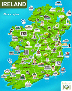
Cultural Map of Ireland